 |
|
Archway - Tower Bank |
Craster Quarry PhotographsThis photograph looks to the Norwell Brow quarry, but the site of the main surviving quarry is still to be dug out.
This view shows the quarry at work and explains why so many men who worked at the quarry in the early part of the twentieth century described their work as 'Quarryman (breaking stones)'.
The next photograph shows the processing plant of Craster quarry, c1900. Dunstanburgh Castle can be made out in the background, the Methodist Chapel behind and West End to the right. The building on stilts is on the site of the present Norwell Brow and serviced Mark Appleby's quarry. The line of the road can be seen veering from West End and running between the afore mentioned building and the buildings in the foreground, which belong to the McLaren and Prowde quarry.
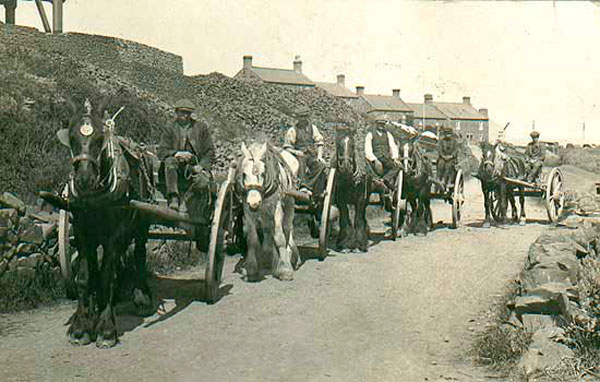
Before the aerial ropeway was built stone was carried to the harbour by cart. The ropeway was only designed to carry crushed stone and the cart continued in use for the larger stone blocks, for making kerbstones, which were loaded onto waiting ships by crane from the north pier. The following photograph shows five carts making their way up the hill to the quarry.
The next photograph shows the bins on the south pier and the pylon on the foreshore. The two black objects against the sky are buckets on the ropeway. The 'goalposts' in the bottom right of the image support a net slung across the road to protect passers by from stone falling from the buckets.
This photograph shows the aerial ropeway operating down the valley, carrying crushed stone to the towers on the pier. The buildings on the right are the 'square', also known as the 'curtyn'. These were fishermans cottages, built in the traditional Northumberland design of an enclosed square. The square was demolished about 1960. In the foreground, the rounded shape appears to be a haystack. The man standing on the road and the little girl behind are taking a close interest in the photographer.
A steamer ready to load stone was in a position that blocked the harbour. This led to some friction with the fishermen. Notice the upside down boat cut in half to make a shed in the centre forground.
This photograph, taken from a position next to the Summer House, shows that there were three bins, the outside two secured to the wall of the south pier with strong beams. The bins were made of wood, banded with iron rings and were some 90ft tall.
|


 |
Home Programme Membership Archive War Memorials History Walk Miscellanea Links Contact Us